Gosport Waterfront Regeneration Area, Gosport
Fort Blockhouse
Blockhouse/Haslar Gunboat Yard forms part of the wider Haslar Peninsula regeneration area that also includes the 23 ha Royal Hospital Haslar site, plus Haslar Marine Technology Park that is home to QinetiQ.
A blockhouse or fortified tower is known to have been located on it from 1417 and as a result of further development there are two scheduled ancient monuments and a Grade II Listed Building.
The site occupies four land parcels known as Blockhouse 1, 2 and 3 and the Haslar Boat Yard.
- Blockhouse 1 (former HMS Dolphin) includes the Submarine Escape Training Tank (SETT) – a Grade II Listed Building – and 33 Field Hospital as well as MoD administration, training, living accommodation and sports and welfare facilities
- Blockhouse 2 includes the RN Submarine Museum and the Joint Services Adventurous Sail Training Centre (JSASTC). The Museum is a popular tourist attraction that will be retained on the site
- Blockhouse 3 (former HMS Hornet) is separated from Blockhouse 1 and 2 by Haslar Road and is used jointly by the JSASTC and the Hornet Sailing Club primarily as a boatyard. The sailing club has a 25 year lease until 2040 with the MoD, plus an option to renew for a further 25 years, for the exclusive use of Blockhouse 3
- Haslar Gunboat Yard includes the underused historic gunboat sheds and yard
- In November 2016 the Government published its “Better Defence Estate” strategy that included the proposal to dispose of Blockhouse 1 in 2020. The release date is now envisaged to be 2023/24.
Location / Access
The site is adjacent to the mouth of Portsmouth Harbour and has a frontage with the Solent and Haslar Lake. It is connected to Gosport Town Centre by Halsar Road which crosses Haslar Creek and served from the south-west by Clayhill Road and Fort Road that provides direct access to Stokes Bay.
Options
The Blockhouse and Haslar Gunboat Yard area provides a significant opportunity to create a new heritage/leisure quarter focussing on the strengths of its Harbour-mouth location, historic buildings and the Royal Naval Submarine Museum. As with other sites it will be important to replace the existing employment on the site. The intensity of use on the whole site is considerably lower than when it was a submarine base. It has recently employed 400 people compared to 1986 when it employed just under 2,500.
Given the limitations of the site’s access roads and the finite capacity of the Haslar Creek bridge any proposed development should not result in significantly more traffic than that arising when the sites were fully occupied by the MoD.
The site has a number of features which are potentially attractive to the marine, marina and associated sectors including: deep and sheltered water close to the Solent; a cluster of marina and other technology businesses close by e.g. Haslar Technology Park; as well as on-site assets which may be suitable for re-use e.g. the diving tank.
The site also has the potential to expand its training and skills potential particularly as the JSASTC is likely to be retained on the site. The marina itself will offer enhanced visitor opportunities and potential for linked employment uses.
Given its strong heritage features including the existing Submarine Museum, the site will be an attractive location for residents and visitors to spend time and consequently has the potential for a number of tourism/leisure uses including hotel/conferencing facilities, arts/craft studios, food and drink establishments and heritage interpretation attractions. Other employment opportunities will need to be considered including small scale offices and workshops.
It is acknowledged that housing will assist bringing forward the employment objectives for this site. A developer will need to demonstrate that the proposed level of residential development is required to: help facilitate the delivery of employment generation on the site; protect heritage assets; or represents the most appropriate re-use of an existing building. Consideration will also need to be given to the sea defence and the risk of flooding on parts of the site, and also to other site uses and constraints.
Planning Status
The Haslar Peninsula is identified in the adopted Gosport Borough Local Plan 2011-2029 as Regeneration Area 3 (Policy LP6) as part of a vision to regenerate Gosport through the delivery of high quality sites. As part of this Blockhouse will offer new opportunities for tourism, leisure and marine employment and training. The emerging Gosport Borough Local Plan 2038 includes further details of how the site could be developed.
Developer/Owner
Blockhouse 1, 2 and 3: owned by the Ministry of Defence
Gunboat Yard: TBC
Description:
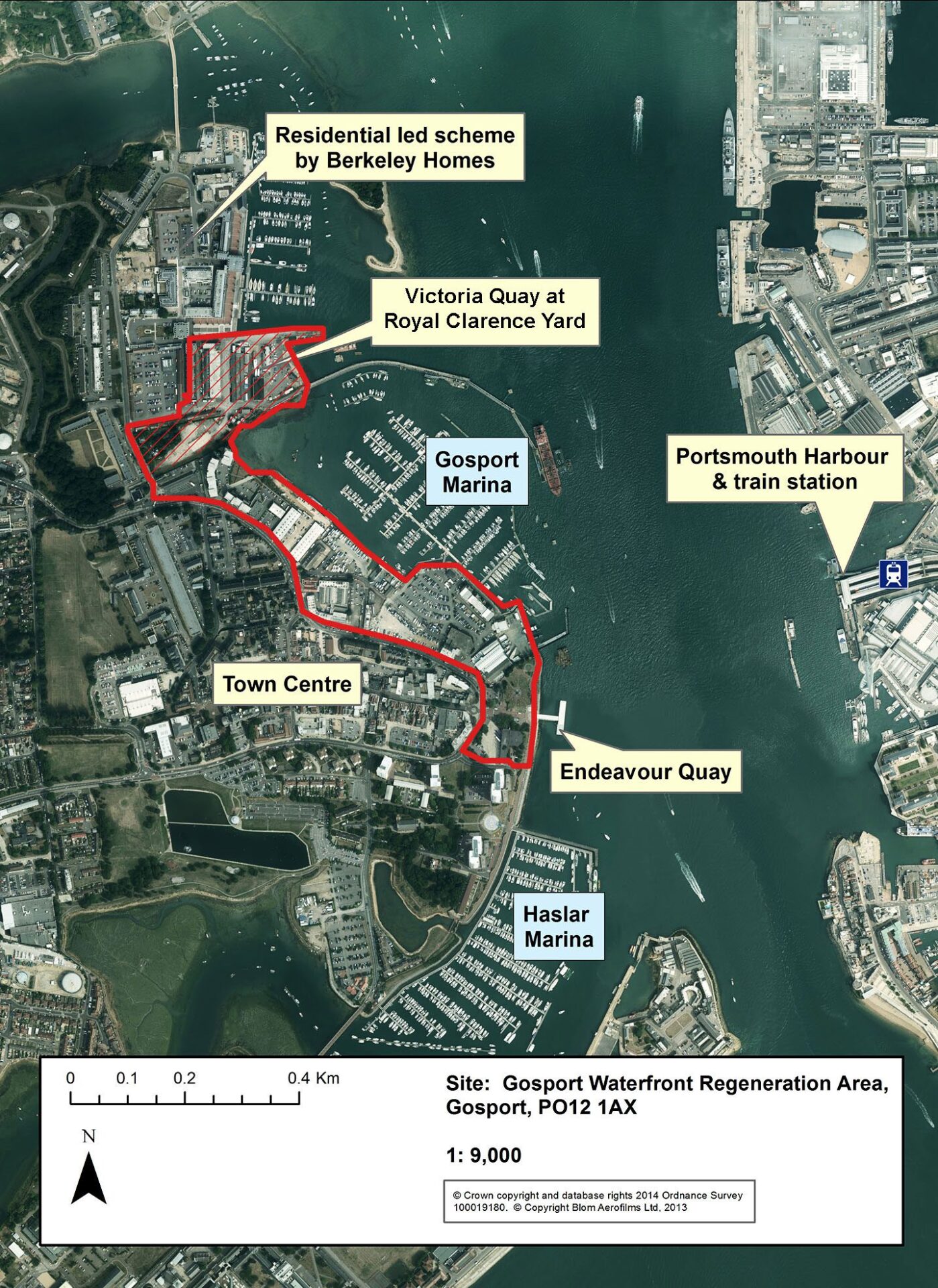
The Gosport Waterfront Regeneration Area covers a long section of coastline from the Victoria Quay adjacent to Royal Clarence Yard (RCY) through to the Gosport Bus Station and the passenger ferry terminal. The area has been identified as having potential for redevelopment and intensification as part of a mixed-use scheme including employment related uses, particularly within the marine sector.
Gosport Waterfront Regeneration Area has been identified in the Solent LEP’s Strategic Economic Plan as a priority area for redevelopment and can accommodate marine related businesses who require deep water access, presenting the opportunity to become a key waterfront employment site for the Solent.
Land being brought forward for development includes:
- The Gosport Waterfront Gateway site (PO12 1EP), a 0.83ha (2.17 acres) prime waterfront mixed-use development opportunity. Situated in a prominent position at the far eastern end of Gosport High Street, with stunning views across Portsmouth Harbour, it is envisaged that the development will include prime waterfront residential (circa 100 units), mid-size hotel opportunity, retail, offices, visitor centre and heritage interpretation space, food and drink, public realm and a new transport interchange.
- Victoria Quay at RCY, a 3.77 ha (9.20 acres) site that adjoins the Berkeley Homes residential led Royal Clarence Yard development and Royal Clarence Marina. Recently purchased from the MoD by UK Docks it will be developed as a hub for a wide range of modern high-tech marine services as well as boatyard services complimenting other such facilities around Portsmouth Harbour.
- Gosport Bus Station development site extends to 0.6 ha (1.5 acres). The site is adjacent to the Gosport/Portsmouth Ferry Terminal and the planned £5.9 million new bus interchange. The Gosport Bus Station building which currently occupies the property extends to approximately (9,700 sq ft) and is currently in use. It is a mixed use development opportunity including retail, hospitality and residential. (Subject to Planning)
The opportunity:
Suitable for office, research & development, light industrial, retail, leisure, residential uses and marine related uses.
Location:
The Gosport Waterfront Regeneration Area is situated on the western side of Portsmouth Harbour overlooking the Historic Dockyard and Gunwharf Quays. It is well connected with the proposed new transport interchange (Bus Station and passenger ferry terminal), which links Gosport with Portsmouth harbour mainline railway station with its links to London. Principal road access is via the A32 that links with Junction 11 of the M27.
Planning status:
The Gosport Waterfront Regeneration Area is allocated as a key employment site under Gosport Borough Council’s Local Plan (2011-2029) (adopted October 2015) policy LP4. The policy estimates that approximately 33,000 sq. m (gross) of employment floor space could be developed, providing a range of premises for light industrial (B1c) and general industrial (B2) uses. The policy allows for the reconfiguration and intensification of employment uses on the site to facilitate the development of other employment uses, including offices, retail, tourism and leisure.
The Gosport Waterfront Regeneration Area is also subject to the council’s Gosport Waterfront and Town Centre Supplementary Planning Document (SPD) adopted March 2018.
For more information see gosport.gov.uk
Plot size & estimated employment floor space provision:
| Area | Plot Size (ha) | Plot size (acres) |
| Gosport Waterfront Total | 11.018 | 28.57 |
| Gosport Bus Station | 0.83 | 2.17 |
| Victoria Quay at Royal Clarence Yard | 3.769 | 9.19 |
Development considerations:
- The Gosport Waterfront Gateway is an important point to the town and a key element of the redevelopment will include a new ferry/bus interchange linking buses that serve Gosport and Fareham, plus providing the ferry connection to Portsmouth and national rail services.
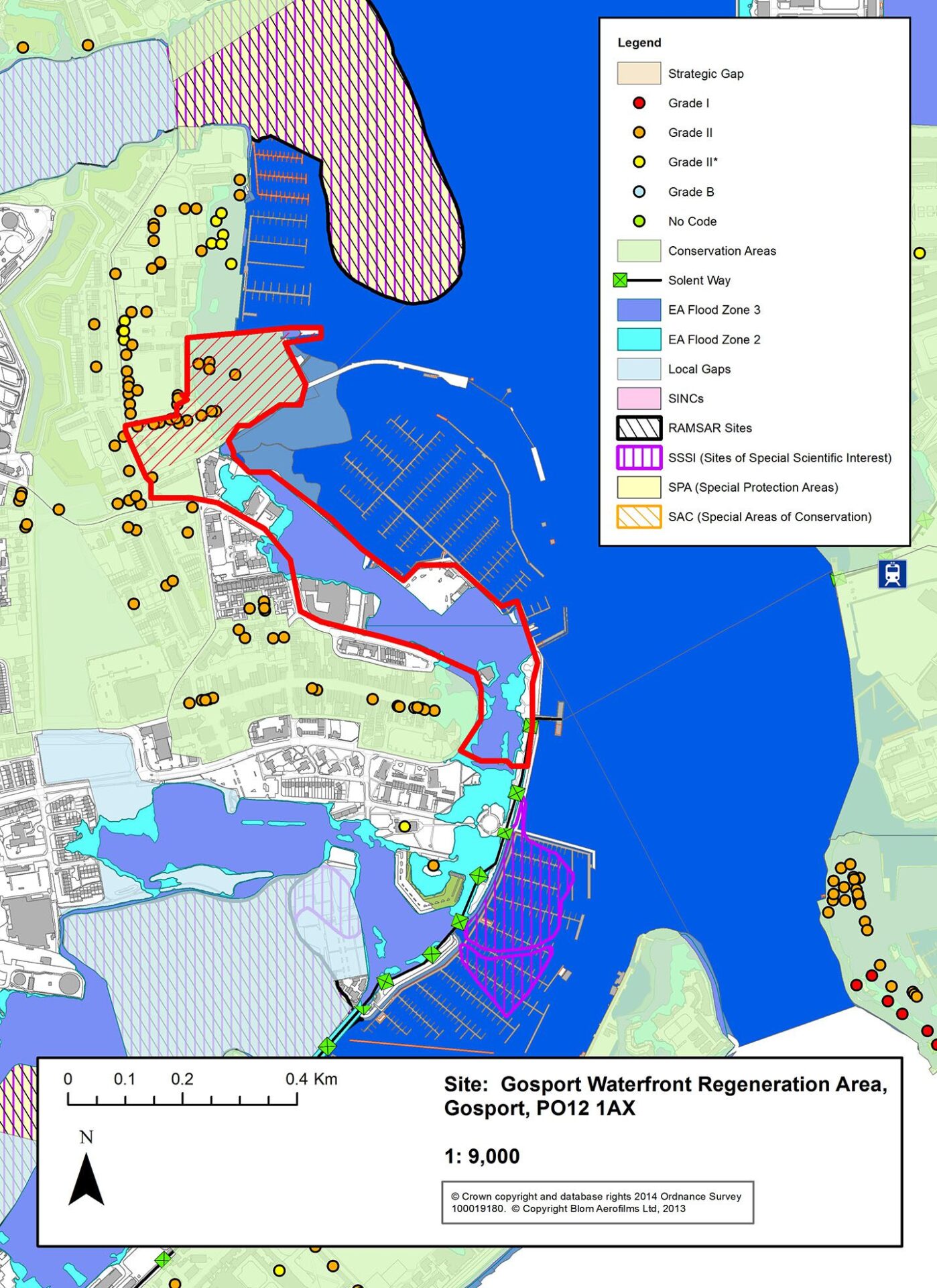
- The Gosport Waterfront Regeneration Area includes the Conservation Areas of Royal Clarence Yard and St Georges Barracks South, and is within 500 metres of the Portsmouth Harbour RAMSAR, SPA and SSSI.
- The Gosport Waterfront Regeneration Area benefits from access to deep water facilities at the Victoria Quay (RCY) and at Premier Endeavour Quay within Gosport Marina, which have to be safeguarded.
- The Gosport Waterfront Regeneration Area is in the main within Flood Zone 3, with some parts of the site located in Flood Zone 2.
Local authority: Gosport Borough Council
Development address: Gosport, PO12 1AX
You can find out more about our Marine and Maritime sector in Hampshire here.

